44°44′30″N 65°30′55″
Annapolis Royal (2006 Population 444) iThe community is situated at the western end of the fertile Annapolis Valley, nestled between the North and South mountains which define the valley wiki

The valley measures approximately 150 km in length from Digby and the Annapolis Basin in the west to Wolfville and the Minas Basin in the east, spanning the counties of Digby, Annapolis and Kings, but geographically speaking they are part of the Avon River valley. wiki
Annapolis Royal's main attractions are the English Fort Anne Historic site

Fort Anne, situated at the junction of the south bank of the Annapolis River and Basin (Annapolis Royal, Nova Scotia), was initially the site of the second French (Acadian) community of PORT-ROYAL.
Captured by New England and British troops in 1710, the fort and town were renamed Fort Anne and Annapolis Royal after Queen Anne. As one of the oldest continuously occupied sites in North America, this settlement became the first capital of peninsular NS following the Treaty of UTRECHT (1713).
Captured by New England and British troops in 1710, the fort and town were renamed Fort Anne and Annapolis Royal after Queen Anne. As one of the oldest continuously occupied sites in North America, this settlement became the first capital of peninsular NS following the Treaty of UTRECHT (1713).
Port Royal known as the Habitation at Port-Royal,

In 1710, Port-Royal surrendered for the last time to British forces who renamed it Annapolis Royal after Queen Anne (1665-1714), the reigning monarch. The name is formed through a mix of the former French name Port-Royal and combining the queen's name with that of 'polis', the Greek word for city. The Annapolis Basin, Annapolis River and the Annapolis Valley all take their name from the town. Under the French reign, Annapolis River had been known as Rivière Dauphin.


People of the Annapolis Valley have come together every year since 1933 to celebrate Spring and take in the breathtakingly beautiful apple blossoms that blanket the trees throughout Nova Scotia’s premier apple-growing region.
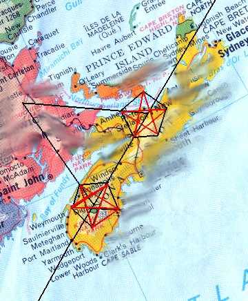
Growing up I thought the place Ecum Secum was imaginary , & the Beatles where from Liverpool 'Nova Scotia', untill i was told there was a liverpool in UK and Ecum Secum is an actual Nova Scotia town. I do notice that NS mirrors a lot of places & is higly synchy. ( IE - with oak island money pit, Sid the Kid, Bubbles, Sloan, Squid, 1/2 to the equator, PEI potato head, Avalon, Arcadia... )
The number 8 highway from Annapolis (Anna_polis) leads across the heartland of Nova Scotia, through Queens lands, crossing the 103 highway to Halifax and transforms into #3 before it hits Liverpool. Liverpool is the port of "privateers" here's a little sync wink photo i took in Liverpool


I just notice the "bow" in the back pointing to the eye ;)

Right:Ringo is "apple" in Japanese.

That puts a whole new spin on Annapolis Royal if Anna is apple like in Eden, Annapolis Royal was the first settlement in Canada & the town of Digby (sirius) just down river.


Digby, voted as the most romantic Canadian town, famous for the Digby scallops fleet & the Ferry through the Gut to St John, she just happens to be called "Princess of Arcadia"
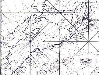
![[_pickv3.gif]](https://blogger.googleusercontent.com/img/b/R29vZ2xl/AVvXsEi-BQDB6VI2mdQE7RxCoGQPqoJlHb7_6QdknLLvkuDPOCyRyrN0xvqkdBF0QXHWaCg3nl9rtB3PsVLpyq0kDodMG9F5qBh1wCxArEGzk2glu2pI1PXuuHiqJnQ515433ntScwv6Ducgowo/s1600/_pickv3.gif)
Digby sits on the right arm w/ the symbol of Venus/Female


Digby sits on the right arm w/ the symbol of Venus/Female


Botticelli's Birth of Venus has Venus rising from the foam in a scallop shell. In the ancient world of the Mediterranean, this theme of Aphrodite's (Venus's)
Annapolis was voted most voted the 2004 "Most Liveable Small Town in the World" and the 2008 winner of the International "Communities in Bloom" Award

Halifax
Water runs up hill @ capstone in Moncton where AC/DC is set to play 'Magic Mountain" magnetic hill its only been in the last few years this area has seen large acts , like the Stones, Kiss, Paul, Nickleback. It's a huge battle now between Halifax commons and Magnetic Hill for venues.
July 4th Virgin festival @ the commons then 7 days after, on the same grounds (July 11) Paul McCartney will be playing his only show here in Canada -- >* note the street /park names - like "bell st. " Then 7 days later, the Tallships and Kiss hit the city (rumors have it Paul will be sticking around)

Ogdoad Creation myth all things are 8 ( infinity) 2 to the power of 3 = 8 - the 23 enigma / 2(f) +3(m) =5


2 comments:
interesting post, although the Scots' earliest presence in Nova Scotia was Charlesfort at present site of Annapolis Royal...may as well mention them
and the ferry through Digby Gut goes to Saint John, not St. John, and is the 'Princess of Acadia,' not "Arcadia".
Thanks John. When i lived in St.John... we always abbreviated Saint, force of habit :)
you are correct, St.John ferry "Arcadia" was a typeo :) I'm sure this blog has few!
Acadia/Arcadia/kadie/a'qati/ acadie/l’arcadie/Arkadia/Arcady/Arkadía/Αρκαδία linguistically they are pretty much all in the same.
Post a Comment